Defining Regions in Upstate New York
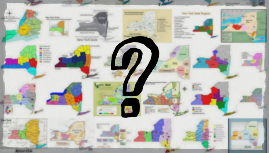
Defining regions in Upstate New York can be a difficult task. Let’s take a look at some maps and the different ways Upstate is divided by region.
by Chris Clemens
The New York times has written about it. People on Twitter have tweeted about it. Brooklynites have yelled about it over a coke and a slice. No one can agree on where Upstate New York actually exists.
If you ask someone from the Hudson Valley, they might tell that you Upstate is north of Rockland County. But, if you ask someone who has never left New York City, you’re probably going to find that they think Upstate begins at Stony Point and Syracuse is somewhere in Canada. If you talk to someone in Plattsburgh, they might even tell you that they’re so far north that they’re beyond being Upstate.
It’s a puzzle that will probably never be resolved and that’s fine.
But, if you’re from New York State and traveling, where do you say that you’re from? As a resident of Rochester, I can tell someone I’m from New York and they ask how close I was to Ground Zero on 9/11. I have to explain, I’m from Upstate New York–nowhere even close to the Five Boroughs. If they are persistent, they might want to know where in Upstate.
And, that’s tricky.
Where Are The Regions In Upstate
What I’ve always found intriguing is the regions in Upstate and how we define them. If you did a very scientific poll on Twitter asking what region Rochester is in, you might get Finger Lakes for an answer, or some will say Western New York. If you drive south and talk to someone in Corning, they might also identify with the Finger Lakes region. Or, they might tell you they’re from the Southern Tier.
Rochester, New York is located in the ___________ Region of the state.
— Chris Clemens (@cpclemens) December 19, 2017
Utica is pretty close to Central New York, but there are plenty of claims to the Mohawk Valley. Gloversville on the bottom edge of the Adirondack Region, was originally put on the map for, you guessed it: glove making. Even though many of those gloves were made of leather, Gloversville had nothing to do with the Leatherstocking Region. So, here’s another scientific Twitter poll:
Utica, New York is located in the ___________ Region of the state.
— Chris Clemens (@cpclemens) December 20, 2017
Surely, if I did some researching, I could easily find out what the defined boundaries were for each region.
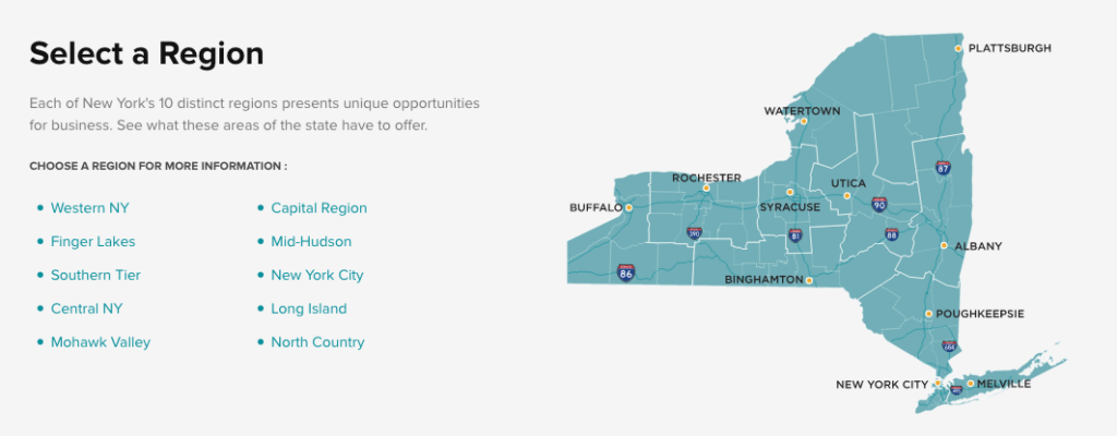
Official Upstate New York Regions
The official Empire State Development program puts Rochester right in the Finger Lakes. But, it also puts Albion of Orleans County in the same region. Albion is about an hour and fifteen minutes by car to the northern tip of Conesus Lake, its nearest Finger Lake. Though, interestingly, Niagara Falls is only a few minutes shorter. So, I guess Albion can be in the Finger Lakes.
But, then why would Steuben County get lumped into the Southern Tier when it owns nearly half of Keuka Lake’s waterfront?
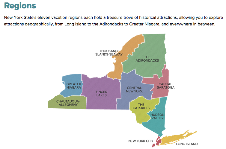
I checked in over at one of my favorite programs to see how Path Through History (PTH) broke things up. PTH is operated by the previously mentioned Empire State Development in conjunction with the NYS Department of Transportation. But, each department has a slightly different map!
PTH does put Rochester in the Finger Lakes, but they break Chautauqua-Allegheny in to its own region altogether.
More interestingly, they spell it “Allegheny”, which is typically a Pennsylvanian thing. In New York, we usually spell it “Allegany”, like the county.
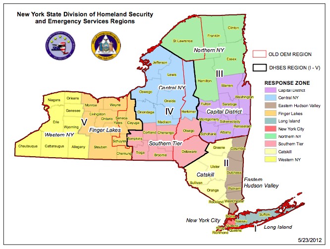
Surely, the state’s office for Homeland Security can be considered an authority on geography! But, according to them, you can be in Alexandria Bay on the St. Lawrence River, just a stone’s throw from the Canadian border and somehow still be in Central New York.
How about a weather source? Trackers use maps constantly and each region in Upstate has a pretty different climate controlled by its proximity to a lake. I thought a weather resource might be a good way to determine how the state is divided. As you probably have already guessed, they also rained on my parade.
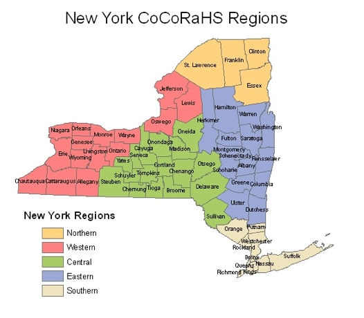
The Community Collaborative Rain, Hail & Snow Network (CoCoRaHs) at Cornell keeps things pretty simple with only five regions. But, in this one, Oswego County is included with Western New York. That means you could be in Cayuga County and drive east into Western New York! That’s not a universe I can live in.
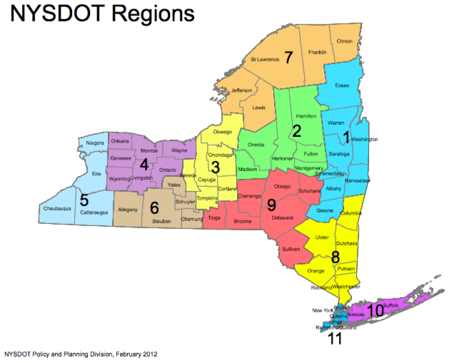
It’s easy to imagine that anyone in charge of transportation would have a solid handle on boundaries. Just as you’d expect, the New York State Department of Transportation does has a method for assigning regions to local offices. Their map is actually not that different from the Empire State Development office. But, they primarily use number codes to identify regions.
Each number does have a more common name like “Central New York” (No. 3), but in this one there is no Finger Lakes Region, they call Region No .4 the “Genesee Valley Region”. Except, they end the Genesee Valley at the south edge of Wyoming County.
Some geologists might seriously disagree.
Unofficial Regions In Upstate
How about just one more?
Timothy McDonnell runs a website called Regions of New York State. Unfortunately for this discussion, McDonnell makes it even more complicated. He also uses the Genesee Valley term, which is absolutely a moniker that someone from Rochester might identify with. The Genesee River is unique in so many ways, and it has helped to shape the city, and the surrounding areas. Furthermore, he extends the Genesee Valley Region right down to Pennsylvania.
But, on this map, people in the Catskills would most closely associate with New York City. If this were the 1950’s and NYC Jews were still vacationing at Grossinger’s that might be acceptable. But in 2017, Manhattan is ffffaaaarrrr from Sullivan County.
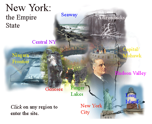
However, the more I looked at this map, the more I liked it! Buffalo gets to hang with the folks in Jamestown. Rochester is sort of hanging with all the people along the Genesee River. Ithaca gets to be in the Finger Lakes and the people in Roscoe on the edge of the Catskills get to associate with….Nah.
I can’t let that go.
But there is one element to this map that the others are missing. An element that in my opinion is probably one of the most important.
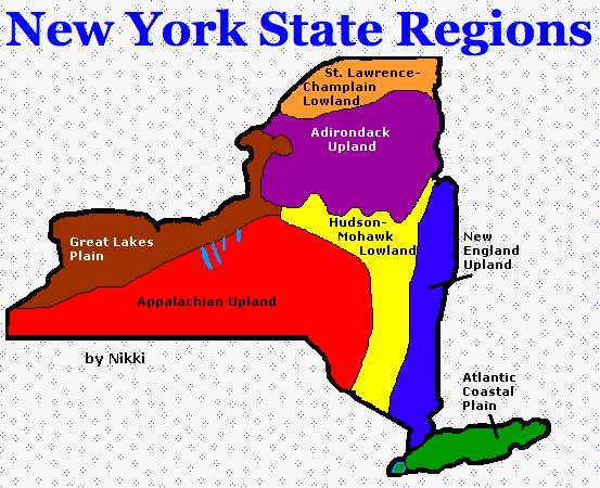
If you’re curious to know how someone who didn’t care about political votes, tax revenue, or financial responsibilities would divide the state up, so was Mrs. Biltucci who teaches fourth grade history at the Central Valley School District in Ilion. One of her students kind of nailed it with only seven regions. So, we have the Appalachian Upland to thank for those delicious spiedies in Binghamton.
Also, why did it take going to a 4th grader to finally get someone to mention the Great Lakes?
How These Maps Exist
Clearly, there are reasons that each of these groups have drawn their borders. I’m guessing the weather folks at CoCoRaHs would agree that Oswego County isn’t known for chicken wings. But, when it comes to lake effect snow conditions, that eastern border of Lake Ontario will have similar weather patterns to Buffalo than it will to the Adirondacks.
When a program has a fiscal budget they need to determine how best to appropriate that funding. They’ll determine where the money is coming from and where it needs to be spent. So, even though Ithaca sits perfectly on the southern edge of Cayuga Lake, the funds generated through taxation help support economic programs in the Southern Tier. Though it kind of unearths an awkward truth about public funds and dividing the state, it gives power to the map from the economic development program.
More confusing though, is that tourism programs spend money to promote things in the Finger Lakes which Ithaca would no doubt benefit from. If you want to start a business in Ithaca that would bring in tourists and you’re seeking a grant of some sort, you’d actually be striking up a conversation with the Southern Tier.
How We Think the Upstate Regions Are Divided
While discussing this with a friend from Rochester, she reminded me that when we were growing up, our phone numbers began with 716, just like Buffalo. Western New York had an entire area code! That was stripped of Rochester in 2001 when they created 585. Suddenly, Buffalo seemed kind of….long distance.
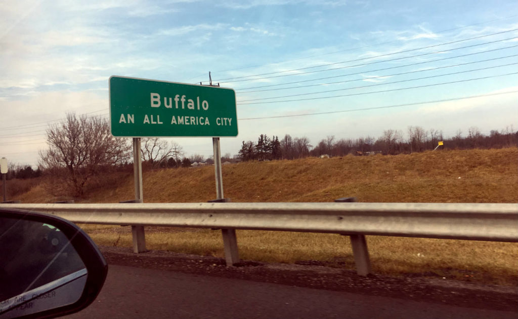
Unless, of course, you were a Buffalo Bills fan. We don’t have an NFL team in Rochester, so football fans have always claimed the Bills as a hometown favorite. In fact, they do their practices at Saint John Fisher College, so it’s easy to feel like a Western New York-er without even leaving Pittsford.
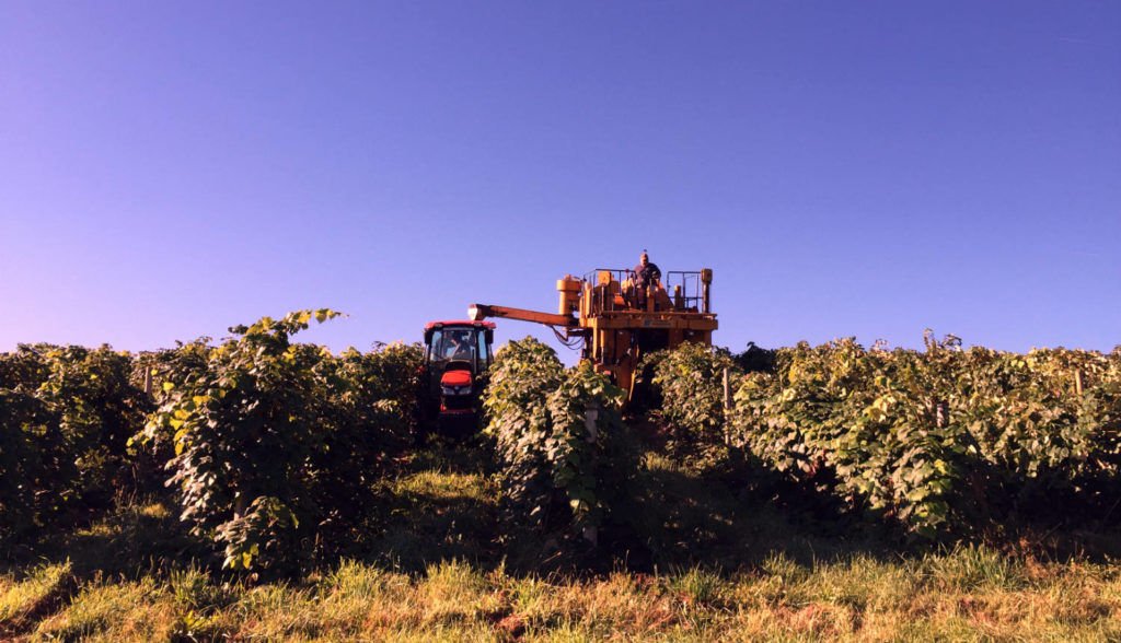
But, what if you don’t watch football? Or, follow Sabres hockey? What if you’d rather spend a Sunday driving through the hillsides of the Finger Lakes tasting a Riesling? There’s a good chance you’ll identify more with the Finger Lakes Region.
What if you live in Schenectady which is just a few miles west of Albany? Because, I know people in Albany who have said, “Ohh. Nooooo. Schenectady is Mohawk Valley. They’re not with us in the Capital Region.” Buuutttt, why? It started to seem like this discussion wasn’t at all about borders, but more about culture. So, I reached out to my good friend Dr. Lindsay Bell, Professor of Anthropology at SUNY Oswego. She explained:
Boundaries are the products of human culture. They are always contested and contingent on larger historical and political economic circumstances. While we may feel as though regional identities come from within, they actually emerge from the process of imagining, reinforcing, or reconfiguring boundaries. It is in our relationships to “others” that we gain a sense of self and community. Boundaries are made and reinforced through interactions like fighting over regional boundaries on twitter, or debating whether or not you should put ranch on pizza (no thanks, Long Island).
These subtle acts can pull us closer to imagined others or can create a separation between us and those who may be physically very close by. These ‘lighter’ conversations and identity debates usually do link back up to questions of class and social inequality. With the uneven distribution of wealth in the state of New York, some may want to identify with wealth, while others have developed strong counter identities. The interesting questions about boundaries as an anthropologist are who is trying to create them? What symbolic means are they using to do so? (soda vs pop? Chicken wings? football?) What is at stake in these debates? Why is this particular debate happening now?
How Regions In Upstate Are Defined: FINAL ANSWER
So, you want to know the final answer on how New York’s many regions are divided? The answer is: Pride. Regional Identity. You live in the region of New York State that you most closely identify with culturally!
You might live in Marcellus right on Otisco Lake (which only loosely considered a Finger Lake), but if you’re a Syracuse Basketball fan, you’re gonna reap that Central New York pride and tell outsiders that’s where you live. If you’re from Rochester and visiting Seattle talking to another football fan, you’re going to stake your claim to Western New York and then have them take a video while you jump on a plastic beer pong table in the parking lot.
You want to be excited about where you’re from, just like me!
And, that’s why Timothy McDonnell’s blurry map is so important. People drive upwards of an hour to get to work in some areas. People move to the next town over, or the next county over. When they do, they cart their culture with them. Buffalo had Polonia where the Polish settled and set up a small version of their homeland. Syracuse has Tipperary Hill where the Irish settled after building the Erie Canal. But, as people began moving out of those neighborhoods, the cultural identity of the neighborhood changed.
The Polish that left the Broadway-Fillmore area were still Polish. They were just Polish in a neighborhood that now had Italians, Irish, and Germans. If I move from Rochester to Medina, is it really so far away that I couldn’t still say I’m a Rochesterian?
Luckily, I could probably just create a map to support my claim. And, that’s all that counts.
Afterward
Got your own way of splitting up New York in to regions and fancy yourself an artist? Send me your own map and if I get enough, I’ll share them in another post!
Chris Clemens is the Founder/Publisher of Exploring Upstate. From his hometown in Rochester, he spends as much time as possible connecting with the history, culture, and places that make Upstate New York a land of discovery. Follow him on Twitter at @cpclemens

January 14, 2018 @ 10:09 am
In regards to Gloversville and the Leatherstocking Region, it was my understanding that the term “Leatherstocking Region” referenced James Fenimore Cooper’s series of novels–The Leatherstocking Tales (The Last of the Mohicans being the most famous). Since the books largely took place around Otsego Lake/Cooperstown and the Susquehanna River, that part of the state, a bit further west and south and Gloversville, became referred to as the Leatherstocking Region. As a literature lover, I thought I’d mention the connection. Love the blog! Keep up the good work! 🙂
January 14, 2018 @ 10:25 am
You’re 100% right that the origins for the words “Leatherstocking Region” refer back to Fenimore’s books! It’s my understanding, that after establishing the moniker for the surrounding counties to Cooperstown, that outlying tourism groups latched on to the success of the region, and the “leatherstocking” term began to mean different things and take on new borders. Only in the last decade or so, I think people have decided it should no longer be used at all. That alone could be a research topic all its own.
And, glad you’re enjoying following along, Jenn! Thanks for contributing to the discussion!
January 14, 2018 @ 9:46 pm
My opinion as someone who has lived in the Perry/Castile (Letchworth State Park) area my whole life: draw a line from Watertown down to Syracuse, then down to Binghamton. Anything East of that? I’ll let the people who live there fight over what they call themselves, although I think of it all as Upstate. Anything west of that line, for me, is Western NY. I consider the Fingerlakes to simply be a region/area WITHIN Western NY, not a separate region.
I very much dislike sports, but even so, I’ll still root for the Bills ANY day (although please don’t expect me to wear any paraphernalia)! And even though I identify with Rochester over Buffalo, probably because we get Rochester television stations on our over-the-air tv’s and do our major shopping there, I proudly tell Southerners that I come from the home of the original Buffalo Chicken Wings 😉
And when I’m traveling and people ask where I’m from? I adamantly proclaim: “Western New York State”!
Thanks for your blog–I enjoy it so very much!
January 14, 2018 @ 10:10 pm
Ha! Regions within regions could be a whole other topic! This one would be a bit of a rabbit hole to fall into.
Glad you enjoyed, Suzie! And, I appreciate your thoughts on dividing things up—yours would be an easier map to draw, for sure!
January 15, 2018 @ 11:54 am
Hi Chris
I really enjoy your blog. I hail from Lewiston (Niagara Frontier), but have spent most of my life in Cattaraugus County. Living on the Canadian-US border has inspired hours of pondering the meanings of borders, boundaries. Often I have felt more Canadian than American. To tell the truth, though I am “a grass is always greener on the other side of the fence kind of person.” That said, I think of myself primarily and “simply” as a Western New Yorker. I have explained to interested parties that Catt. Co. is in SW NYS…one county east of the farthest western county, Chautauqua or I say ‘it’s in the Southern Tier, right above Pennsylvania” or where Ellicottville, home to the “Aspen of the East,” or near Allegany State Park, or…my favorite…where there are two Seneca Nation Territories…one surrounding the city of Salamanca, which used to call itself “the only city in the county entirely on an Indian reservation,” today however, people may know it for the casino, and the second territory known as the “Cattaraugus Territory” further north…the name Cattaraugus lends its name to the territory, the county, the main waterway, Cattaraugus Creek, and the village closest to me. What is the meaning of “Cattaraugus”? I have heard in Seneca it means “smelly banks” referencing the natural gas escaping from creek beds and banks. I have not however checked this out with a Seneca speaker.
But I digress…
I was especially pleased when I read about the fourth grade class’s map; this week I will start volunteering in a fourth grade classroom, which is researching their small town’s history in honor of its bi-centennial coming up this summer. This article is a perfect springboard. I know we will have fun looking at these maps.
As you know better than most, small doesn’t mean empty.
P.S. Actually there are many people in this area who believe it has more in common with the Midwest, than the Northeast or Mid-Atlantic states.
January 23, 2018 @ 7:54 am
Great thoughts on this, Candace. It’s interesting that you associate so much with Canadian culture! I’ve visited Lewiston a few times, but probably am not in touch enough to recognize Canadian influence outside of Lewiston just being a town that is new to me. Next time I visit, I’ll be seeking authentic poutine. 🙂
January 15, 2018 @ 12:03 pm
Almost forgot…one of my pet peeves in the way NYS Travel Guide labels this region: “Chautauqua-Allegany.” No mention of Cattaraugus! Thanks a lot, guys!
January 23, 2018 @ 7:55 am
Haha! I totally get what you’re saying, but to mention all three would make it a loonnnggg name!
January 16, 2018 @ 1:20 pm
An Amazing Blog Chris… to take a note from Suzie, it is also interesting how media has helped shape a regional or subregional identities in the state -particularly that old school television and radio (back when it was independent stations that is). Their “markets” help to culturally identify regions. Used to live in an area that made no sense to hold a subscription to any of the local newspapers because one was focused on the greater Saratoga area and the others were more south/southwest into the Fulton & Montgomery Counties.
January 23, 2018 @ 8:01 am
That’s a great point. And, modern media, too. When this site first launched, I was concerned that I’d catch blowback from people not liking that I used the word “Upstate”. Within the last few years, I’ve seen a lot of digital media brands begin to use the term in their branding. Maybe the modern definition is changing exactly because of your point–media not only reaches certain markets, but helps shape ideas, too.
And, thanks for your kind words about the blog. Glad you’re enjoying! There are always areas we can do better, but no need to be “a concerned upstater”! 😉
January 16, 2018 @ 9:47 pm
Isn’t northern NY just part of Lower Canada anyway, eh?
Pretty good look at the various state “regions” by agencies and the lack of continuity. The conclusion of regions really being an actualization of the community culture is an appeal notion as well Chris. Finding the old I Love NY or NY Tourism Marketing regions to compare to older versions of similar agency regions would be interesting to see if/when and perhaps why those regions have shifted for those organizations as well.
January 23, 2018 @ 8:08 am
Funny you should mention this about Canada. Checkout one of the previous comments here from Candace associating with Canada despite living in (what I would call) Western New York.
I’ve been looking through eBay the last couple months to try and find more vintage New York tourism ephemera. I think it would be super fun to dig some up and compare their work to what is out there today. In fact, I wonder how many of the destinations in some of those guides still even exists!
January 20, 2018 @ 7:08 pm
I’ve always considered Schoharie, Montgomery, and Fulton Counties (don’t confuse Fulton County for either the City of Fulton or the Town of Fulton) as part of the Greater Capital Region. I find people in those counties are more likely to travel to Albany than Utica or Syracuse. Granted other people will argue otherwise.
January 23, 2018 @ 8:10 am
That’s one of the things that was fun about looking into this topic–you can find two people from the same area who have two opposing thoughts on how things are. As long as its always civil, I think the discussion will always be a fun one!
Upstate News You Can't Use: Freak Accidents |
July 27, 2019 @ 9:01 am
[…] leads me to wonder if a quick poll of readers could reveal the regional differences even in Upstate New York of what people call that carbonated sugar beverage… Soda Water being the one my father used for […]
August 18, 2019 @ 11:46 am
I love your blog and your discoveries! Regarding regions, I grew up in Catskill, which most people I’ve met through life were shocked to learn there was a Catskill village in the Catskill Mountains. (Which, geologically, are actually a “mature dissected plateau.” See Wikipedia entry. 🙂 )Then I came to Rochester to attend the UofR and became confused over soda vs pop and other “controversies.” Now that I’ve lived here for over half of my life, I’m a “naturalized” citizen. That is, it’s all natural to me now. Thanks for such an interesting and fun topic!